
Idaho -
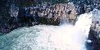
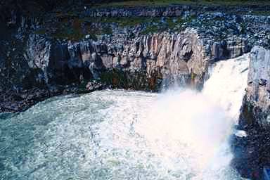
Upper Mesa Falls, Idaho, U.S.A.
Regions
North Idaho South Idaho
Get Around
It's all driving or flying.
By car
There are two segments of freeway that cross the state, I-90 for roughly 60 miles across the panhandle in the North, and I-84 for a couple hundred miles in the South (ok, someone pointed out a few miles of I-15 in far Eastern Idaho). The rest of the roads are two lanes, and often curvy and hilly (but scenic!). A few "highways" aren't even paved. You know you're from Idaho when your elderly grandparents think it's normal to arrive at Christmas (or even just for a weekend visit) after driving 400 miles through blizzards and along winding two lane river roads.
To the East, the Continental Divide (West of which rivers flow to the Pacific, East of which rivers flow to the Atlantic) meanders down the spine of the Rockies, and defines the border with Montana. A handful of passes cross the Divide. In the winter, check with the highway department for pass conditions -- many passes are closed from the first snow until mid-April.
There is no convenient way to get from North Idaho (Moscow) to Eastern Idaho (Idaho Falls), since there are no roads that go directly through the rugged mountains (and the "Idaho Primitive Area.") Instead, you would have to drive 300 miles to Boise, then another 300 miles East to Idaho Falls. Or you could drive North to I-90, East through Montana, then South to Eastern Idaho. Either way, you'll drive 600 - 700 miles when it's something like 300 miles as the crow might fly.
By plane
Flying is an expensive but wonderful way to get around and see the majestic scenery. Backcountry flights are available from many airports in the state, and you get to fly through canyons and into remote airstrips that are nearly unreachable any other way. Examples are McCall Aviation and Selway Aviation in Central Idaho. If you just want to go city-to-city, call Horizon Airlines.
Stay Safe
The weather in Idaho can be fickle and extreme compared to other parts of the world. Mountains make their own weather, and it can be sunny one moment and stormy the next. If you are taking part in some outdoor activity, be prepared. For example, if you are hiking in the backcountry, take The 10 Essentials. Most importantly, use your common sense.
Idaho is one of the Rocky Mountains states of the United States of America. Idaho is a rugged state, with 10,000 - 12,500 ft (3000 - 3800m) snow-capped mountains, whitewater rivers (one running through the deepest river canyon in the U.S.), forests, high desert, and plenty of wilderness. Most of the land north of Boise is National or State Forest. The state's capital and largest city is Boise. Residents are called "Idahoans."
According to the United States Census Bureau, in 2004, Idaho had an estimated population of 1,393,262. The state's postal abbreviation is ID. Idaho is nicknamed the Gem State because of its abundance of natural resources. The state motto is Esto Perpetua (Latin for "Let it be perpetual").
Southeastern Idaho, with its sparse topsoil, was greatly affected by the rising water level of prehistoric Lake Bonneville to the south, a lake which covered most of what is now the states of Utah and Nevada. At a point roughly near Twin Falls, the rising waters broke through into the region in an ancient, massive flood, channeling the floodwater westward for what is estimated to have lasted for approximately seven weeks, almost completely draining the ancient lake and creating the massive, lengthy, and spectacular Snake River Canyon that we know today. The massive flood stripped the region's topsoil down to bedrock, tumbling huge, multi-story high boulders downstream, where eventually the boulders and other heavier materials dropped out and were deposited in and along the Snake River streambed. The stripped topsoil, a much lighter material, eventually was deposited well to the west, creating fertile farming regions well adapted to growing potatoes. Because of the great flood and the stripping of the region's topsoil, much of the agriculture in southeastern Idaho's thin layer of topsoil must be supported by fertilization and irrigation.
Idaho's nickname is "The Gem State," although the motto on the license plates is "Famous Potatoes," with the unfortunate result that anyone who has heard of Idaho imagines the state as a vast expanse of potato farms, with grizzled inhabitants living in cabins with no running water. In reality, the cabins mostly have running water.
The other common misconception is that Idaho is somehow a racist or Neo-Nazi state. Around 1980, a Neo-Nazi and White Separatist brought a band of followers to Hayden Lake, Idaho and began regularly making the local and national news with his racist provocations. Although the local residents vigorously disapproved and regularly held much bigger counter-demonstrations, the Neo-Nazi image has stuck. Idahoans breathed a collective sigh of relief in 2001 when the 20 acre compound owned by the "church" was handed over to a woman who had filed a lawsuit against them after being assaulted by their guards, and many of the racists left the state. Idaho was admitted to the Union on July 3, 1890, as the 43rd state.
Climate
The state of Idaho has much variation in its climate. Even though the state is located 300 miles away from the Pacific Ocean, the maritime influence is still felt in the state especially in the winter when cloud cover, humidity, and precipitation are at its highest point. Conversely, this influence has a moderating effect in the winter where temperatures are not as low as would be expected for a state with a mostly elevated altitude. This maritime influence is lowest in the southeastern part of the state where the precipitation patterns are often reversed with wetter summers and drier winters and seasonal temperature differences more extreme, showing a more continental climate.
Summers in Idaho can be hot, although extended periods over 100 °F or the maximum temperature are rare. This is tempered by the low relative humidity during summer months and also by the cooler evenings, since for most of the state, the highest diurnal difference in temperature is often in the summer. Winters can be cold, although extended periods of bitter cold weather below zero are unusual.
Get In
By plane
Flights come in to all cities, plus some of the towns. Alaska Airlines and its subsidiary Horizon Airlines are the best, but United, America West, and Southwest Airlines serve Idaho as well.
For South Idaho, you might fly in to Boise, or drive in from Salt Lake City.
If you're going to Yellowstone, you'd probably want to fly in to Idaho Falls then drive up to the West Yellowstone park entrance.
If you are going to Northern Idaho Coeur D Alene book a flight to Spokane, Washington.
By car
You could also drive to North Idaho from Seattle or more easily from Spokane.
Attractions
In the winter, skiing, snowshoeing, snowboarding, snowmobiling, and even camping are popular outdoor activities, both with tourists and residents. In the summer, Idaho has world-class boating (try a jet boat leaving from Lewiston), whitewater rafting, camping, hunting, fishing, mountain biking, and hiking. Rodeo is also popular in the more rural areas. Lewis and Clark National Historic Trail runs through North Idaho, through the twin cities of Lewiston, Idaho and Clarkston, Washington.
There is now a bike trail running through the North. It goes from the east all the way to Montana.
Other trails that are popular include The Route of the Hiawatha trail, Latah Trail, Bill Chipman Trail of the Palouse, and Trail of The Couer D'Alenes. The trails range anywhere from 7 miles to 80 miles long. The rails-to-trails project is responsible for transforming abandoned train routes to hiking, biking, and walking trails. One of the longest trails in the nation is being worked on in Northern Idaho.
Idaho has more whitewater rivers than any other state excluding Alaska.
Top-destination ski resorts include Saint Anthony Sand Dunes and Brunaeu Sand Dunes. The newest and least crowded is Tamarack Resort.
Sun Valley -- the first great ski resort in the U.S.
Rugged mountains including Mount Borah, Idaho's tallest at 12,662 feet.
Raft the Middle Fork of the Salmon River, Stanley. This trip is usually six days long and includes world class fishing, hot springs, and class III - IV rapids.
Craters of the Moon National Monument -- volcanic park with vast fields of seemingly lifeless lava, fun lava tubes to explore
Frank Church River of No Return Wilderness -- follows the Snake River through Hells Canyon (as deep as 9,300 feet, much deeper than the Grand Canyon) north towards Lewiston, where the Clearwater and Snake River meet
Yellowstone National Park -- Second only to Yosemite as the most majestic National Park in the lower 48 states, but weirder, more colorful, and more spectacular, filled with hot springs, geysers, and fumaroles. Mostly within Wyoming, but the most notable feature, Old Faithful is probably most easily reached from Idaho Falls via West Yellowstone, Montana - though the park road is only open in summer (May to early November).
The Nez Perce Indian Reservation, home to Native Americans whose forebears helped Lewis and Clark through the winter during their expedition, is just East of Lewiston.
City of Rocks National Reserve -- Located on the southern edge of the state. Popular with hikers and rock climbers for its maze of massive boulders (some over 100 meters in height).
There are many bald eagles in the North. A good place to see them is Lake Coeur d' Alene. Take I-90 East and exit at the Harrison exit.
Bruneau Canyon Overlook provides a view into a 1,200 foot-deep, 800-foot-wide river canyon.
Quick Facts
The longest highway in a national forest in the U.S. is the Lewis & Clark Highway, which is also the shortest route from the Pacific Coast to the mid-west.
Soda Springs is claimed to be the largest man-made geyser in the world.
North America's tallest structured sand dune measuring 470 feet is located in Bruneau Dunes State Park.
Hell's Canyon is the deepest gorge in the country.
Adapted from WikiTravel under the Wiki License
Home | Add/Modify Listing | Photo Gallery | Maps | Contact | About Us | Canada Privacy Statement
This site is operated by 2024 Cedar Lake Software
LastModified: Apr-13-10