Maps in Eastern Region, Massachusetts (MA) - Listings United States
 USA > Massachusetts > Eastern Region > Travel > Maps
Page 1 of 1
1796 Map of Martha's Vineyard (Dukes County)
Click again on the map to see the surrounding area! from 'The State of Massachusetts from the best information, 1796.' Published by J. Reid, New York. Found in 'First Census of the United States, ...
http://history.vineyard.net/mv1796.htm
1914 Map of Vineyard Haven (Tisbury)
1914 Vineyard Haven Click on the map below to visit. See full map of surrounding areas. Area 1: South Main Street area Area 2: Owen Park / Woodlawn Ave. area Area 3: Franklin Street area Area 4: ...
http://history.vineyard.net/vh1914/
1937 Boston Area Highway Map (Boston)
Boston and Vicinity, 1937, © General Drafting Company for the Colonial Beacon Oil Company (Esso). Click on map for larger image.
http://www.schlichtman.org/mahighways/boston37.html
Aerial Photos of Framingham (Framingham)
Introductory text about 1997 aerial photo-shoot in Framingham, MA
http://www.framingham.com/history/aerial97/intro.htm
ArpaNet Maps (Burlington)
ARPANET Maps These maps are from Heart, F., McKenzie, A., McQuillian, J., and Walden, D., ARPANET Completion Report, Bolt, Beranek and Newman, Burlington, MA, January 4, 1978. Folks - I just ...
http://som.csudh.edu/cis/lpress/history/arpamaps/
ben-yosef.com (Boston)
VERSE Robert Frost Robert Worsham ben-yosef.com Saturday, April 24, 2004 BOSTON PHOTOS Boston Public Library Faneuil Hall Night Snowfall Trinity South End War Protest May Public Garden Boston ...
http://www.ben-yosef.com/
Boston (Boston)
%PDF-1.2 %âãÏÓ 3 0 obj endobj xref 3 45 0000000016 00000 n 0000001244 00000 n 0000001522 00000 n 0000001725 00000 n 0000001906 00000 n 0000001928 00000 n 0000025135 00000 n 0000025157 00000 n ...
http://www.lib.utexas.edu/maps/national_parks/boston_nhp99.pdf
Boston Atlas (Boston)
http://www.mapjunction.com/places/Boston_BRA/
Boston Harbor Cam (Boston)
Live web cam with a view of the Boston Harbor. The Boston Harbor WebCam updates whenever motion is sensed.
http://www.bostonharborcam.com/
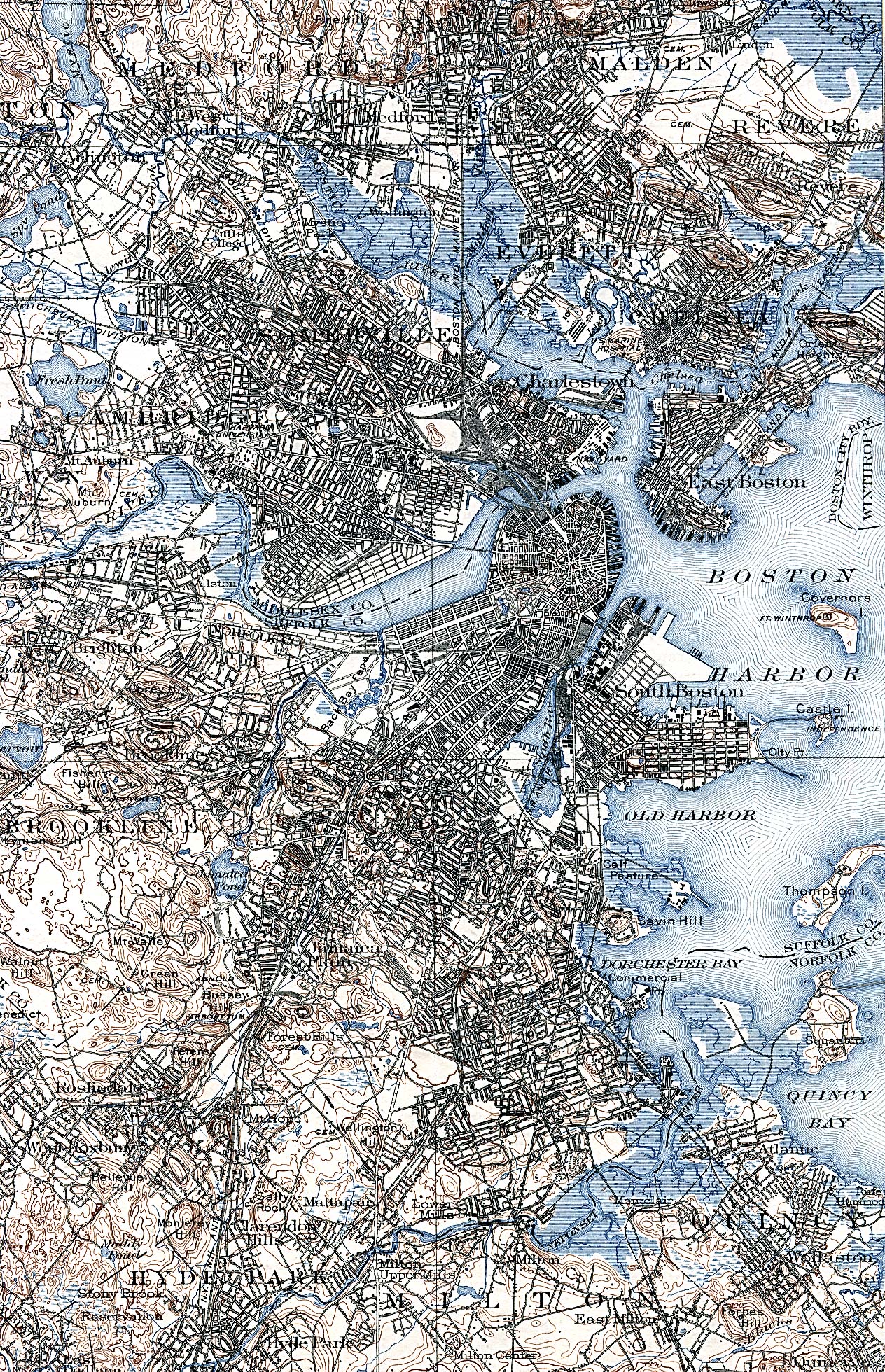
Boston in 1903 (Boston)
http://www.lib.utexas.edu/maps/historical/boston_1903.jpg
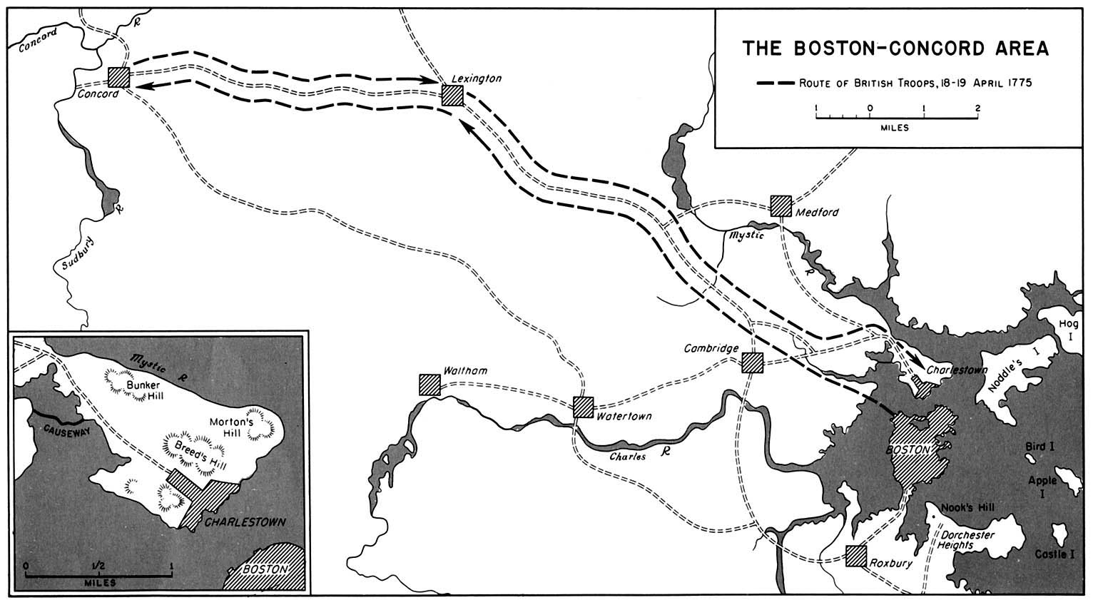
Boston-Concord (Boston)
http://www.lib.utexas.edu/maps/historical/boston_concord_1775.jpg
Cape Cod Web Cams (Nantucket)
Cape Cod - real estate, lodging, dining, recreation, shopping and entertainment for Cape Cod and the islands of Martha's Vineyard and Nantucket, Massachusetts.
http://www.clickcapecod.com/content.asp?section=10
Digital Atlas of Boston (Boston)
Digital Atlas of Boston, Massachusetts and Vicinity Professor William A. Bowen California Geographical Survey Department of Geography California State University, Northridge A Dr. William A. Bowen ...
http://geogdata.csun.edu/bospg1.html
Downtown Boston Route Map (Boston)
Downtown Boston, 1952, from the AAA Northeastern States map, © American Automobile Association. Click on map for larger image.
http://www.schlichtman.org/mahighways/boston52.html
Falmouth, MA Quadrangle (Falmouth)
UNH DIMOND LIBRARY Documents Department Data Center Historic USGS Maps of New England New York Falmouth, MA Quadrangle USGS 15 Minute Series Latitude 41.625 Longitude 289.375 1893 northwest corner ...
http://docs.unh.edu/nhtopos/Falmouth.htm
Gay Head Light (Aquinnah)
Gay Head Light Martha's Vineyard, Massachusetts Gay Head Light sits 160 feet above the sea on the brightly colored clay bluffs of the Western side of Martha's Vineyard, where the Devil's Bridge ...
http://lighthousegetaway.com/lights/cod5.html
Hampstead-Haverhill, NH-MA Quadrangle (Haverhill)
UNH DIMOND LIBRARY Documents Department Data Center Historic USGS Maps of New England New York Hampstead-Haverhill, NH-MA Quadrangle USGS 15 Minute Series Latitude 42.875 Longitude 288.875 1893 ...
http://docs.unh.edu/nhtopos/Hampstead-Haverhill.htm
Holmes Hole, 1858 (Tisbury)
Holmes Hole, 1858 (Inset from: Map of the Counties of Barnstable, Dukes, and Nantucket Massachusetts by Henry F. Walling, 1858. Published by D. R. Smith Co., Boston. A copy can be found at the ...
http://history.vineyard.net/walling.htm
Information Integrity (Maynard)
Focus on running your business and let Symantec focus on your computer security solutions and IT needs. Learn more about finding business security solutions that are tailored to your company.
http://www.information-integrity.com/
Map of Framingham Schools (Framingham)
Map of Framingham Schools Home | Annual Report | District News | District Information | School Web Pages Curriculum | Parent Information Center | MCAS Information |
http://www.framingham.k12.ma.us/map.htm
Map of Vineyard Haven (Tisbury)
Maps of Tisbury and Dukes County 1784 Map of Dukes County (97k) J. Reid's 1796 Map of Dukes County U.S. Navy 1847 Coast Survey of Holmes Hole (356k) Henry F. Walling's 1858 Map of Holmes Hole ...
http://history.vineyard.net/maps.htm
MapQuest : Map of Medfield (Medfield)
Map search of Medfield, Massachusetts provided by MapQuest. The consumer's choice for online maps and directions.
http://www.mapquest.com/maps?city=Medfield&state=MA
Maptech (Amesbury)
Maptech Topo Maps NOAA Nautical Charts GPS interface, USGS topo maps (topographic maps) CD with FREE navigation software with GPS interface. Electronic (digital) NOAA nautical charts for marine ...
http://www.maptech.com/
Maptitude City Guide to Newton, MA (Newton)
Points of Interest | Population Maps | Parcel Maps | Map Index Welcome The Maptitude City Guide to Newton, Massachusetts offers a one-stop resource for accessing a wide variety of data
http://www.caliper.com/newton/
Maynard Vistas (Maynard)
HOME Town Hall Schools Library Dining Businesses Calendar/News Civic Orgs. Our History Arts Religion Sports Neighbors, etc. Maynard Vistas Index Description Java Viewer Image Only Intersection of ...
http://web.maynard.ma.us/arts/vista-index.htm
Old Photographs of Vineyard Haven (Tisbury)
Old Photographs of Vineyard Haven, Mass. Photo Album #1 These photographs were collected by local historian Stan Lair (1902-1987) during the 1970's and 1980's from a wide variety of ...
http://history.vineyard.net/photos/
Suffolk County Massachusetts 1895 (Suffolk County)
SUFFOLK COUNTY MASSACHUSETTS 1895 1895 U.S. Atlas Massachusetts 1895 U.S. Atlas Main Title Page Livingston County MI - USGenWeb Project Page USGenNet.org - The 1st ONLY 501c3 host for genealogical ...
http://www.livgenmi.com/1895/MA/County/suffolk.htm
TopoZone (North Chelmsford)
Interactive USGS topo maps of the entire United States
http://www.topozone.com/
TopoZone - Medfield, MA Topographic Map (Medfield)
Interactive USGS topo maps of the entire United States
http://www.topozone.com/map.asp?z=19&n=4672462&e=309270&size=m
TopoZone: Framingham (Framingham)
Interactive USGS topo maps of the entire United States
http://www.topozone.com/map.asp?lat=42.27917&lon=-71.41667
UNH Dimond Library (Provincetown)
UNH DIMOND LIBRARY Documents Department Data Center Historic USGS Maps of Provincetown, Massachusetts Alphabetic Map Listing Provincetown 15 Minute 189? Provincetown 7.5 Minute 1944 1944 Reprinted ...
http://docs.unh.edu/towns/ProvincetownMassachusettsMapList.htm
Page 1 of 1
USA > Massachusetts > Eastern Region > Travel > Maps
LastModified: Jan-02-13 V4
Home |
Add/Modify Listing |
Photo Gallery |
Maps |
Contact |
About Us |
Canada
Privacy Statement
This site is operated by 2024
Cedar Lake Software
