
Portland - Getting Around -
Walking
Portland is a great city for walking. Many intersections are designed with pedestrians in mind, and Portland has a lot of street life for an American city. Good mass transit also makes walking more feasible in Portland.
Biking
Several streets in Portland are designed to be predominantly for bicycle use. These streets, such as SE Ankeny, SE Salmon, SE Lincoln, and SE Clinton, are usually spaced about halfway between the main car thoroughfares in the grid of East Portland. The bike streets are generally signed with green "Bike Route" signs. Additionally, many major streets have striped bike lanes.
Maps of bike trails can be obtained from Metro, in the Bike There! section.
TriMet and other Public Transport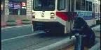
TriMet maintains Bus and Light Rail throughout the Portland area, and City of Portland maintains the Streetcar line which runs through downtown and Northwest Portland.
C-Tran runs buses in Clark County, Washington. Fares for TriMet, C-Tran, and the Portland Streetcar are all interchangeable. Also available is a extensive system map available for a small cost from the tri-met store in Pioneer Square
For mapped point to point Public Transportation directions visit Google Transit:
Adapted from WikiTravel under the Wiki License
Home | Add/Modify Listing | Photo Gallery | Maps | Contact | About Us | Canada Privacy Statement
This site is operated by 2026 Cedar Lake Software
LastModified: Apr-13-10