
View This category in: USA
 State Wide
A Collection of Connecticut MapsConnecticut Maps: Shaded relief map / County map / Black and white map Satellite image / 1895 map (Big: 1.83 Mb) / PostScript map External Links: YaHoo / Excite / US Web Finder / Galaxy / The ...
http://fermi.jhuapl.edu/states/ct_0.html
Connecticut Counties
Home | Contact | Add/Modify Link | Copyright Home: Connecticut Connecticut Counties - pdf (141k) Last Modified: Jul 10, 2005
http://mapz411.com/maps/ct_c.asp
Connecticut Maps
Map Room Guide Maps FAQ Maps Home World Africa Americas Asia Australia/Pacific Europe Middle East Polar/Oceans Russia/Republics U.S. Texas Historical Other Map Sites UTLOL - Finding Information ...
http://www.lib.utexas.edu/maps/connecticut.html
Connecticut Maps and Sea Charts
Rare old maps of State of Connecticut by Grace Galleries of Harpswell Maine
http://www.gracegalleries.com/Conn-Listings.htm
Connecticut Road Map
Home | Contact | Add/Modify Link | Copyright Home: Connecticut Connecticut Roadmap - pdf (1,105k) Last Modified: Jul 10, 2005
http://mapz411.com/maps/ct.asp
Eastern Connecticut Enterprise Corridor
Eastern Connecticut Enterprise Corridor Abstract: Connecticut Enterprise Zone ProgramEastern Connecticut Enterprise CorridorFor More Information Contact: Mr. John J. Filchak Executive Director Northeastern Connecticut Council of Governments 125
http://www.ct.gov/ecd/cwp/view.asp?a=1099&q=249774
Naugatuck Valley Enterprise Corridor
Naugatuck Valley Enterprise Corridor Abstract: Connecticut Enterprise Zone ProgramNaugatuck Valley Enterprise CorridorFor More Information Contact:Richard DunneValley Council of Governments 12 Main Street, Rail Road Station Derby, Connecticut 06418
http://www.ct.gov/ecd/cwp/view.asp?a=1099&q=249784
Real Time Camera Images
Connecticut Traffic Cameras Abstract: Traffic CamerasUse the links below to select the roadway and area to view. The Connecticut Department of Transportation (ConnDOT) traffic camera images are updated evey 5 (five) minutes. Javascript must be
http://www.ct.gov/dot/cwp/view.asp?a=1993&Q=290242&dotNav=%7C
Inside Connecticut
1895 Atlas ConnecticutCONNECTICUT STATE POPULATION 746,258 1895 State Map 1895 County Maps 1895 Index to Cities Towns If you feel this website has provided you with information useful to your research and would like to ...
http://www.livgenmi.com/1895/CT/
1943/1953 City Map (Bristol)
Bristol, Connecticut this image is a portion of an image retrieved from University of New Hampshire Dimond Library Historic USGS Maps of New England online collection. This map is from an 1943 ...
http://www.one-barton-family.net/GenProject/maps/bristol1.html
Aero View of Waterbury in 1917 (Waterbury)
Aero view of Waterbury, Connecticut 1917. To change view, select desired zoom level and window size from the options below the Zoom View window and then click on the image. The display will be ...
http://lcweb2.loc.gov/cgi-bin/map_item.pl?data=/gmd378/g3784/g3784w/pm001010.sid&style=gmd&itemLink=D?gmd/temp/~ammem_Cm5G::&title=Aero+view+of+Waterbury,+Connecticut+1917.+
Aero View of Willimantic in 1909 (Willimantic)
To change view, select desired zoom level and window size from the options below the Zoom View window and then click on the image. The display will be centered where you click. To move up, down, ...
http://lcweb2.loc.gov/cgi-bin/map_item.pl?data=/gmd378/g3784/g3784w/pm001030.sid&style=gmd&itemLink=D?gmd/temp/~ammem_Cm5G::&title=Aero+view+of+Willimantic,+Connecticut+1909.+
Anderson Photos: Destruction of a Hamden Landmark (Hamden)
Hamden Industrial Fire, Anderson Legal Photography, Hamden, CT. On-Location evidence photography to Trial Lawyers, Insurance Claims Units and Corporate Risk Management since 1955.
http://www.photog.com/legal/hmdnfire.html
Bridgeport Enterprise Zone (Bridgeport)
Bridgeport, Connecticut Enterprise Zone Abstract: Connecticut Enterprise Zone ProgramBridgeport, Connecticut Enterprise ZoneFor More Information Contact: Max Perez Economic Development Specialist Office of Economic Development City Hall Annex 999
http://www.ct.gov/ecd/cwp/view.asp?a=1099&q=249768
Bristol Enterprise Zone (Bristol)
Bristol, Connecticut Enterprise Zone Abstract: Connecticut Enterprise Zone ProgramBristol, Connecticut Enterprise ZoneFor More Information Contact: Jonathan Rosenthal Director Bristol Dev. Authority 111 North Main St. Bristol, CT 06010 (860)584-6185
http://www.ct.gov/ecd/cwp/view.asp?a=1099&q=249770
Community Helping Hands (Danbury)
Community Helping Hands. Serving all of Connecticut. Companion services, homemaker services, personal care attendants and assited home living with pride and respect.
http://www.communityhelpinghands.com/
Connecticut Courthouse Postcards
Click on any postcard to see a larger view, and read the history of the Court. Postcards Home Court Jigsaw Puzzles Courthouses Today Visit a Courthouse Kids' Stuff Judicial Branch Home ...
http://www.jud.state.ct.us/external/kids/history/postcards/
Connecticut Dept of Transportation Maps
Department of Transportation Request a Connecticut state road map 2002 Connecticut Transportation Maps 2003 Town Road (TRU) Maps Functional Class (FCL) Maps DGN, DXF & DWG formats Traffic Analysis ...
http://www.ct.gov/dot/taxonomy/ct_taxonomy.asp?DLN=40743&dotNav=%7C40743%7C
Connecticut Map - 1895
CONNECTICUT THE FOLLOWING JPG IS A LARGE FILE THAT WILL PROBABLY TAKE A WHILE TO LOAD, IF IT IS TOO LARGE FOR YOUR SYSTEM TO HANDLE, TRY THE COUNTY SIZE PIECES. HOPE THEY HELP ALONG WITH THE DATA ...
http://www.livgenmi.com/1895/CT/state.htm
Essex and Old Saybrook (Middlesex County)
Unique, fun, hand drawn, full color, interactive, maps. Showing the Best of shopping, dining, lodging, attractions, in the Essex, Centerbrook, Ivoryton, areas
http://www.lighthousemaps.com/Saybrook/EssexSaybrookindex.html
Fairfield County Map - 1895 (Fairfield County)
FAIRFIELD COUNTY CONNECTICUT 1895 1895 U.S. Atlas Connecticut 1895 U.S. Atlas Main Title Page Livingston County MI Historical Genealogical Project USGenNet.org - The 1st ONLY 501c3 host for ...
http://www.livgenmi.com/1895/CT/County/fairfield.htm
Hartford County Map - 1895 (Hartford County)
HARTFORD COUNTY CONNECTICUT 1895 1895 U.S. Atlas Connecticut 1895 U.S. Atlas Main Title Page Livingston County MI Historical Genealogical Project USGenNet.org - The 1st ONLY 501c3 host for ...
http://www.livgenmi.com/1895/CT/County/hartford.htm
Hartford Enterprise Zone (Hartford)
Hartford, Connecticut Enterprise Zone Abstract: Connecticut Enterprise Zone ProgramHartford, Connecticut Enterprise ZoneFor More Information Contact: Wayne Benjamin Corporate Project Manager City of HartfordDept. of Development Services 250
http://www.ct.gov/ecd/cwp/view.asp?a=1099&q=249782
Historic USGS Maps of New England: Windsor Locks Quadrangle (Windsor Locks)
UNH DIMOND LIBRARY Documents Department Data Center Historic USGS Maps of New England New York Windsor Locks, CT Quadrangle USGS 7.5 Minute Series Latitude 41.9375 Longitude 287.3125 1946 ...
http://docs.unh.edu/nhtopos/WindsorLocks7.5CT.htm
House District Map
Oversized (4,017 pixels x 3,126 pixels) map showing district divisions for the Connecticut General Assembly House of Representatives.
http://www.cga.ct.gov/red/2001houseplan.htm
Map and Geographic Information Center (Storrs)
University of Connecticut Libraries' Map And Geographic Information Center - MAGIC
http://magic.lib.uconn.edu/
Map of Bridgeport: 1875 (Bridgeport)
NEW SEARCH ERROR: Failed to open configuration file /prd/cfg/.cfg
http://lcweb2.loc.gov/cgi-bin/query/r?ammem/gmd/
Map of Litchfield County (Litchfield County)
Map of Litchfield County Situated in the northwest corner of Connecticut, Litchfield County includes the towns and hamlets of Barkhamsted, Bethlehem, Bridgewater, Canaan, Colebrook, Cornwall, ...
http://www.litchfieldcty.com/ctymap.html
Map of Litchfield County (Litchfield County)
LITCHFIELD COUNTY, CONNECTICUT Litchfield County map© courtesy of The Litchfield County Times Return to Litchfield Topics
http://www.litchfieldct.com/twn/map_lcty.html
Maze Laboratory (Waterbury)
Michael Werner MD: New York male infertility specialist providing medical treatments for, impotence, sexual dysfunction, female sexuality issues, vasectomy reversals, sperm cyrobanking lab, etc.
http://www.mazelabs.com/waterbury.htm
Middlesex County Map - 1895 (Middlesex County)
MIDDLESEX COUNTY CONNECTICUT 1895 1895 U.S. Atlas Connecticut 1895 U.S. Atlas Main Title Page Livingston County MI Historical Genealogical Project USGenNet.org - The 1st ONLY 501c3 host for ...
http://www.livgenmi.com/1895/CT/County/middlesex.htm
New Haven County Map - 1895 (New Haven County)
NEW HAVEN COUNTY CONNECTICUT 1895 1895 U.S. Atlas Connecticut 1895 U.S. Atlas Main Title Page Livingston County MI Historical Genealogical Project USGenNet.org - The 1st ONLY 501c3 host for ...
http://www.livgenmi.com/1895/CT/County/newhaven.htm
New London County Map - 1895 (New London County)
NEW LONDON COUNTY CONNECTICUT 1895 1895 U.S. Atlas Connecticut 1895 U.S. Atlas Main Title Page Livingston County MI Historical Genealogical Project USGenNet.org - The 1st ONLY 501c3 host for ...
http://www.livgenmi.com/1895/CT/County/newlondon.htm
New Milford, CT Quadrangle (New Milford)
UNH DIMOND LIBRARY Documents Department Data Center Historic USGS Maps of New England New York New Milford, CT-NY Quadrangle USGS 15 Minute Series Latitude 41.625 Longitude 286.625 1904 northwest ...
http://docs.unh.edu/nhtopos/NewMilford.htm
Plainville, Connecticut in 1878 (Plainville)
Plainville, Connecticut 1878. To change view, select desired zoom level and window size from the options below the Zoom View window and then click on the image. The display will be centered ...
http://lcweb2.loc.gov/cgi-bin/map_item.pl?data=/gmd378/g3784/g3784p/pm000930.sid&style=gmd&itemLink=D?gmd/temp/~ammem_Cm5G::&title=Plainville,+Connecticut+1878.+
Senate District Map
Map of the state showing district divisions for the Connecticut General Assembly Senate.
http://www.cga.ct.gov/red/2001senate.htm
Stamford, Connecticut (Stamford)
To change view, select desired zoom level and window size from the options below the Zoom View window and then click on the image. The display will be centered where you click. To move up, down, ...
http://lcweb2.loc.gov/cgi-bin/map_item.pl?data=/gmd378/g3784/g3784s/pm000972.sid&style=gmd&itemLink=D?gmd/temp/~ammem_Cm5G::&title=Stamford,+Conn.+
Thompsonville (Enfield)
To change view, select desired zoom level and window size from the options below the Zoom View window and then click on the image. The display will be centered where you click. To move up, down, ...
http://lcweb2.loc.gov/cgi-bin/map_item.pl?data=/gmd378/g3784/g3784e/pm000808.sid&style=gmd&itemLink=D?gmd/temp/~ammem_3PxK::&title=[Bird's-eye+view+of+Thompsonville+(now+Enfield),+Connecticut].+
Tolland County Map - 1895 (Tolland County)
TOLLAND COUNTY CONNECTICUT 1895 1895 U.S. Atlas Connecticut 1895 U.S. Atlas Main Title Page Livingston County MI Historical Genealogical Project USGenNet.org - The 1st ONLY 501c3 host for ...
http://www.livgenmi.com/1895/CT/County/tolland.htm
Topographical Map of Ansonia-Derby-Shelton (New Haven County)
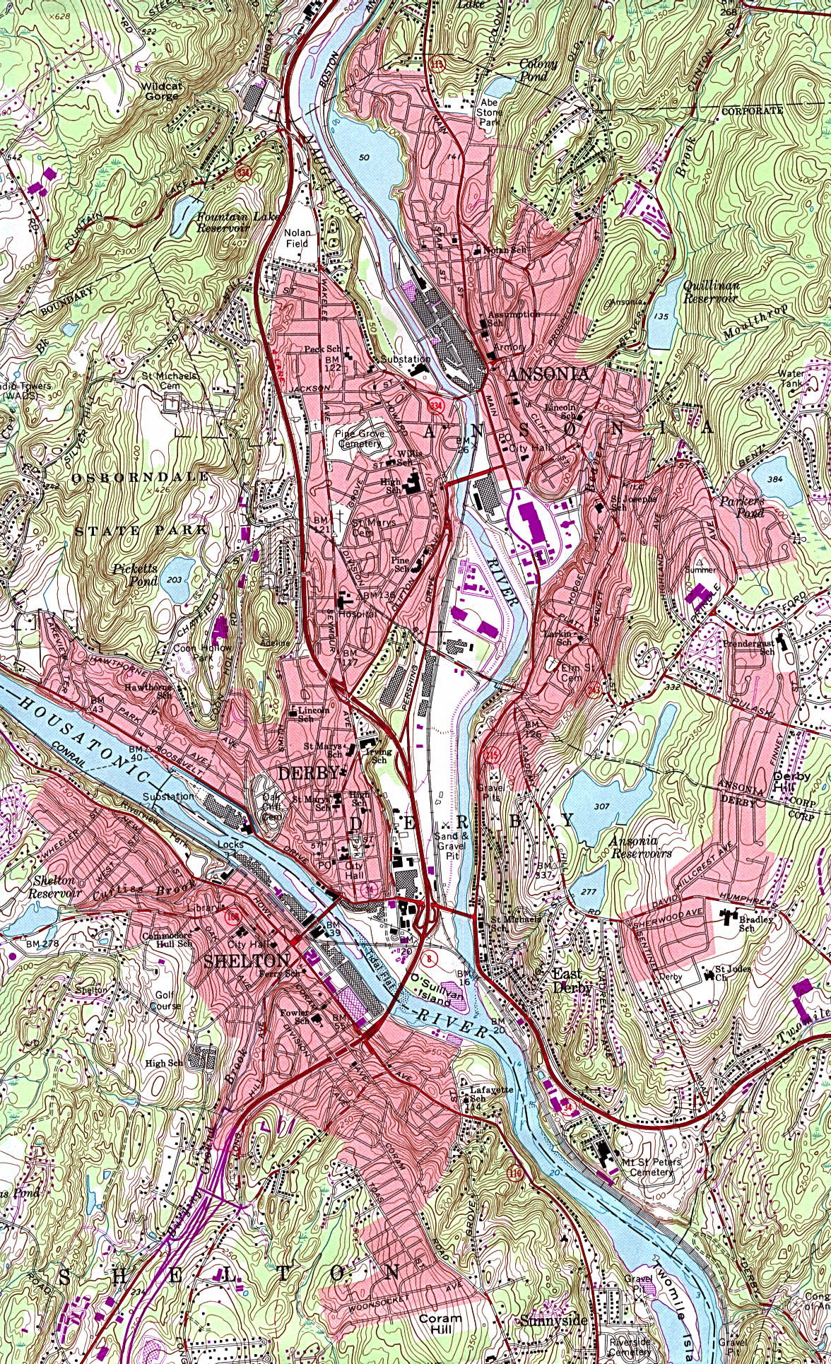
http://www.lib.utexas.edu/maps/united_states/ansonia_conn_84.jpg
Topographical Map of Danbury (Danbury)
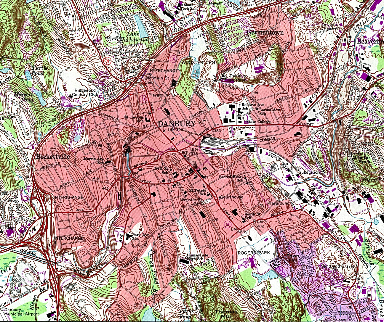
http://www.lib.utexas.edu/maps/united_states/danbury_conn_84.jpg
Topographical Map of Meriden (Meriden)
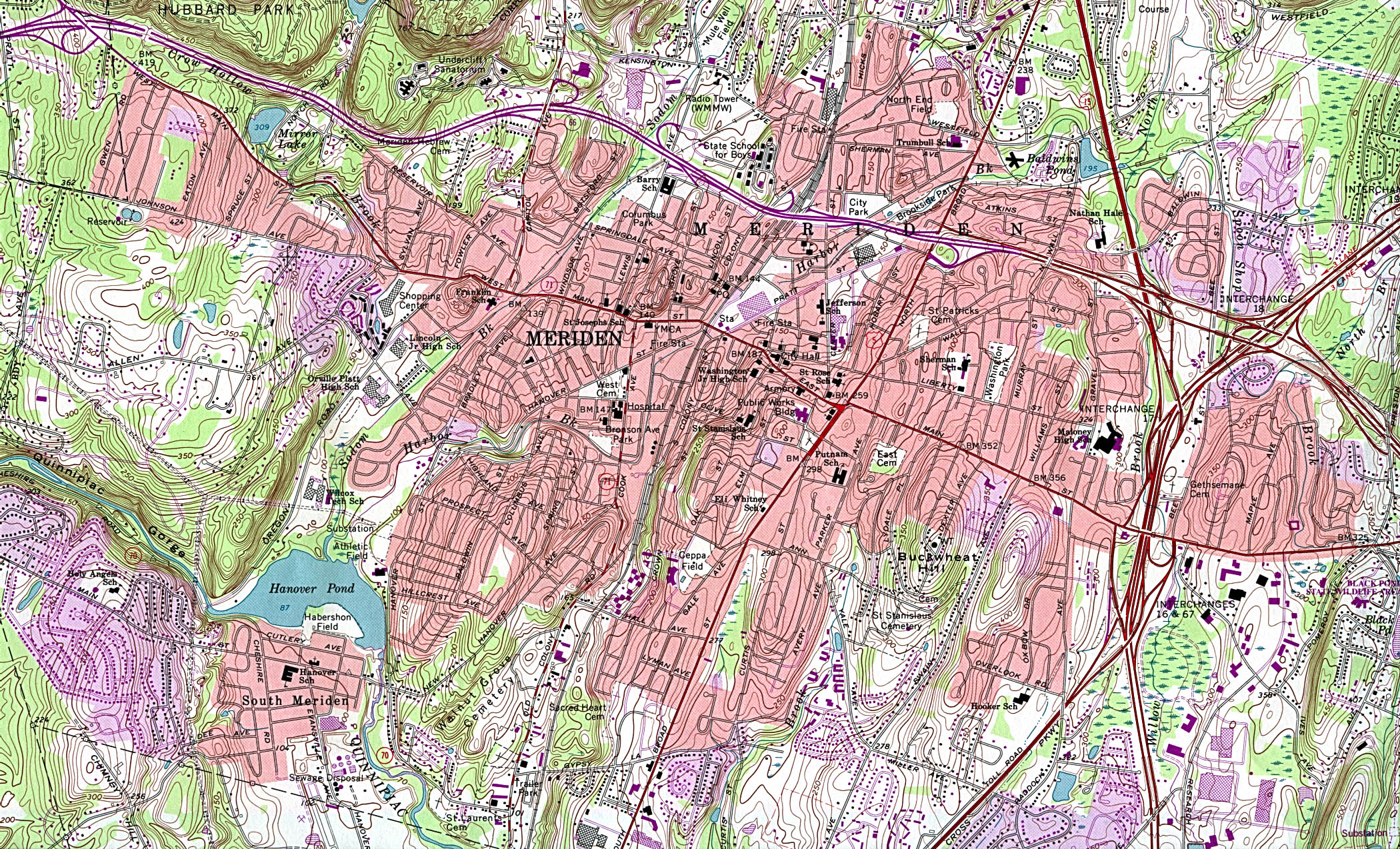
http://www.lib.utexas.edu/maps/united_states/meriden_conn_92.jpg
Topographical Map of Norwich (Norwich)
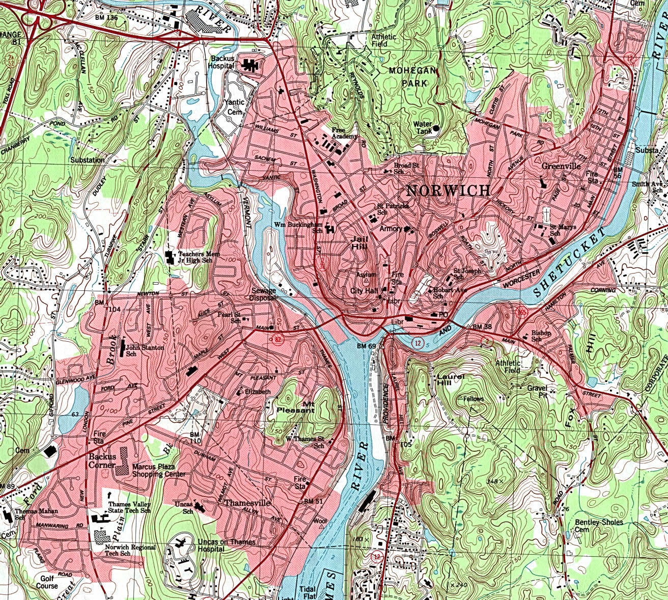
http://www.lib.utexas.edu/maps/united_states/norwich_conn_83.jpg
View of Bridgeport in 1875 (Bridgeport)
To change view, select desired zoom level and window size from the options below the Zoom View window and then click on the image. The display will be centered where you click. To move up, down, ...
http://lcweb2.loc.gov/cgi-bin/map_item.pl?data=/gmd378/g3784/g3784b/pm000773.sid&style=gmd&itemLink=D?gmd/temp/~ammem_3PxK::&title=View+of+Bridgeport,+Ct.+1875.+
View of Bristol in 1889 (Bristol)
To change view, select desired zoom level and window size from the options below the Zoom View window and then click on the image. The display will be centered where you click. To move up, down, ...
http://lcweb2.loc.gov/cgi-bin/map_item.pl?data=/gmd378/g3784/g3784b/pm000780.sid&style=gmd&itemLink=D?gmd/temp/~ammem_3PxK::&title=Bristol,+Conn.+looking+north-east.+
View of Bristol in 1907 (Bristol)
To change view, select desired zoom level and window size from the options below the Zoom View window and then click on the image. The display will be centered where you click. To move up, down, ...
http://lcweb2.loc.gov/cgi-bin/map_item.pl?data=/gmd378/g3784/g3784b/pm000790.sid&style=gmd&itemLink=D?gmd/temp/~ammem_3PxK::&title=Bird's+eye+view+of+Bristol,+Conn.+1907.+
View of Derby, Shelton and East Derby in 1898 (Shelton)
To change view, select desired zoom level and window size from the options below the Zoom View window and then click on the image. The display will be centered where you click. To move up, down, ...
http://lcweb2.loc.gov/cgi-bin/map_item.pl?data=/gmd378/g3784/g3784d/pm000809.sid&style=gmd&itemLink=D?gmd/temp/~ammem_3PxK::&title=Derby,+Shelton,+and+East+Derby,+Conn.,+1898.+
View of Essex, Centerbrook and Ivoryton in 1881 (Middlesex County)
To change view, select desired zoom level and window size from the options below the Zoom View window and then click on the image. The display will be centered where you click. To move up, down, ...
http://lcweb2.loc.gov/cgi-bin/map_item.pl?data=/gmd378/g3784/g3784e/pm000802.sid&style=gmd&itemLink=D?gmd/temp/~ammem_3PxK::&title=View+of+Essex,+Centerbrook+%26+Ivoryton,+Conn.+1881.+
View of Plainville in 1907 (Plainville)
Bird's eye view of Plainville, Connecticut 1907. To change view, select desired zoom level and window size from the options below the Zoom View window and then click on the image. The display ...
http://lcweb2.loc.gov/cgi-bin/map_item.pl?data=/gmd378/g3784/g3784p/pm000940.sid&style=gmd&itemLink=D?gmd/temp/~ammem_Cm5G::&title=Bird's+eye+view+of+Plainville,+Connecticut+1907.+
View of Unionville (Farmington)
To change view, select desired zoom level and window size from the options below the Zoom View window and then click on the image. The display will be centered where you click. To move up, down, ...
http://lcweb2.loc.gov/cgi-bin/map_item.pl?data=/gmd378/g3784/g3784u/pm000981.sid&style=gmd&itemLink=D?gmd/temp/~ammem_Cm5G::&title=View+of+Unionville,+Conn.+
![]() USA > Connecticut > Travel > Maps
USA > Connecticut > Travel > Maps