
Arches National Park -
Rock Arch
Fees/Permits
Park entrance fees are $10 for private vehicles and $5 for individuals on foot, bike, or motorcycle. These fees allow entrance for seven days. Alternatively, the $50 National Park Pass allows free entry to all national park areas for one year.
Getting In
By car
The entrance to Arches is located 5 miles north of Moab along Highway 191.
By bus
Most visitors see Arches National Park on their own, driving automobiles, riding bikes or hiking. However, there are a few privately operated tour companies authorized by the National Park Service to provide visitors with guided trips into the park:
Canyonlands Tours/North American River Expeditions, 543 N. Main, PO Box 1107, Moab, UT 84532, Ph: (800) 342-5938.
Desert Highlights, 50 East Center St., PO Box 1342, Moab, UT 84532, Ph: (800) 747-1342.
NAVTEC Expeditions, 321 N. Main St., Moab, UT 84532, Ph: (800) 833-1278.
Tag-A-Long Expeditions, 452 N. Main Street, Moab, UT 84532, Ph: (800) 453-3292.
Getting Around
By car
A car is the most common way of exploring the park; most visitors will drive to sites and then take short walks to view the amazing geologic formations of the park. There are several four-wheel drive roads in the park's backcountry that may appeal to those with appropriate vehicles.
By foot
There are numerous trails throughout the park, providing an alternative means of travel for those not wanting to spoil the nature experience with a vehicle.
By bike
Although the summer heat can make a bike a masochistic way of viewing the park, in cooler months it can be a popular option. Though there are no bike lanes and traffic can be heavy at times, biking the scenic drive is a great way to see the park. The Salt Valley and Willow Springs roads are less traveled but are more suited to mountain bikes due to washboards, deep sand and other obstacles. Bicycles are only permitted on roads: there is no single track or trail riding in the park. When biking on the main road, please use caution and ride single file on the edge of the lane.
Stay safe
Summer temperatures can reach or exceed 110F (43C), so it is important to carry (and consume) enough liquid to keep you hydrated. One gallon of water per person per day is recommended. When hiking on open rocky areas, be aware that lightning is a danger during storms. Also, the dry sandstone-dominated terrain is susceptible to flash floods during thunderstorms. The most intense thunderstorms occur from July through September, during monsoon season.
Many of the formations within the park are sandstone and can easily crumble when climbing. Numerous individuals must be rescued each year after they scale a formation and then discover that they cannot easily get back down; know your limitations, and be aware that it is usually easier to climb up a formation than it is to climb back down.
The climate is one of very hot summers, cold winters and very little rainfall. Even on a daily basis, temperatures may fluctuate as much as 50 degrees.
History
Throughout the park, rock layers reveal millions of years of deposition, erosion and other geologic events. These layers continue to shape life in Arches today, as their erosion influences elemental features like soil chemistry and where water flows when it rains. Arches is located in a "high desert," with elevations ranging from 4,085 to 5,653 feet above sea level.
In 1923 Alexander Ringhoffer, a prospector, wrote the Rio Grande Western Railroad in an effort to publicize the area and gain support for creating a national park. Ringhoffer led railroad executives interested in attracting more rail passengers into the formations; they were impressed, and the campaign began. The government sent research teams to investigate and gather evidence. In 1929, President Herbert Hoover signed the legislation creating Arches National Monument, to protect the arches, spires, balanced rocks, and other sandstone formations. In 1971 Congress changed the status of Arches to a National Park, recognizing over 10,000 years of cultural history that flourished in this now famous landscape of sandstone arches and canyons.
Attractions
Park Avenue. A relatively easy one mile (one-way) trail located near the park entrance. The trail leads through a steep-walled sandstone canyon with a smooth bottom. Many hikers will get dropped off at one end of the trail and picked up at the other to eliminate the need for a round-trip.
Double Arch. A 0.8 mile roundtrip leads to Double Arch, a massive joining of two arches that will be recognizable from the beginning of the movie Indiana Jones and the Last Crusade. The trail is very easy and located within walking distance of the Windows.
Windows. The North & South Windows, as well as Turret Arch, are located along an easy 1.0 mile roundtrip trail.
Wolfe Ranch. Located near the beginning of the Delicate Arch trail, this ranch is a restored homestead of John Wesley Wolfe, who settled in the area in the late 1800s.
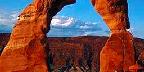
Delicate Arch. The most famous arch in the park (and perhaps in the world), Delicate Arch can be seen from a roadside turnout, from a short 0.8 mile trail, or you can take the 3.0 mile (roundtrip) trail, gaining 480 feet of elevation, and stand underneath this natural wonder. The trail to the arch is strenuous; be sure to carry adequate water with you. Note that during peak season you are likely to be sharing the trail with many people; visiting at sunrise provides the best chance of solitude, while sunset offers the best photography.
Petrified Dunes. An overlook of the petrified dunes lies just off of the park road between the Courthouse Towers and the Windows Area. These colorful formations are ancient sand dunes, hardened into stone as additional layers built up on top of them and were later eroded away.
Fiery Furnace. The Fiery Furnace area is accessible only on ranger-led tours, which can be reserved at the visitor center. The tour leads through a maze of sandstone fins, showcasing one of the most interesting geologic areas in the park. A fee is charged for this tour and tours often sell out quickly, so trips should be booked as early as possible.
Devil's Garden Area. Devil's Garden is a series of sandstone fissures that are home to Landscape Arch (the park's largest), Double O Arch, and numerous others. A series of trails lead to the arches, with Landscape Arch only a 1.6 mile roundtrip from the trailhead, while Double O Arch is a more strenuous 4.2 mile roundtrip.
Klondike Bluffs. Visited by only a very small fraction of the park's tourists, Klondike Bluffs is located in the northwest corner of the park and is accessible only by a dirt road or on foot. Tower Arch is located down a short trail, as is the formation known as the Marching Men.
Activities
Hiking. The park offers numerous short trails (see above) ranging in difficulty from very easy to moderate.
Photography. The park is a photographer's paradise with reddish brown rocks, distant snow-covered mountains, and fantastic rock formations. As with most places, light can be harsh during the day, so it is best to have the camera ready during the early morning hours and late evening hours. Delicate Arch and the Windows are best photographed at sunset, while the light on Landscape Arch and Double Arch is best near sunrise.
Rock climbing. Climbing is not allowed on most features named on USGS maps, but is allowed on other formations.
Backpacking. Limited water supplies and a lack of true backcountry trails limit the appeal of backpacking in the park, although backcountry use is allowed. Inquire at the visitor center for details.
Shopping
There is a bookshop in the visitor center that offers postcards, posters, books of local interest, and a variety of other souvenir items. For a larger selection, the town of Moab has everything necessary to satisfy your shopping needs.
Dining
There is no food or drink available within the park. The nearby town of Moab offers a vast number of restaurants, convenience stores, and grocery stores.
Lodging
There is no lodging within the park, although the nearby town of Moab has an enormous number of hotels to choose from.
Camping
There is only one campground within the park, and reservations are highly recommended. Outside of the park the Bureau of Land Management (BLM) operates several campsites.
Devil's Garden Campground. Located at the end of the park road, this campground has 52 individuals sites and two group sites. Water and flush toilets are available. Costs per site is $10 per night. Between March 1 and October 31 up to 28 individual sites may be reserved. Reservations can be made no less than 4 days and no more than 240 days in advance from or by calling NRRS at 877-444-6777. There is an additional $9 fee for reservations. The remaining 24 sites are first-come-first-served and will be taken shortly after the park opens each day; stop at the visitor center when it opens at 7:30 for the best chance at a site.
Backcountry
Arches is a relatively small park, with very few areas far enough from roads to qualify as backcountry. Outside the developed areas there are no designated trails, campsites, or reliable water sources.
In order to backpack in Arches, you must obtain a free backcountry permit at the visitor center. The maximum group size is twelve, but smaller groups are strongly recommended to reduce impacts. Permits may not be reserved in advance. Backpackers should know how to navigate with a topographic map, recognize safety hazards and practice low-impact camping specific to the high desert. Primary safety considerations include steep terrain, loose rock, lightning, flash floods, and dehydration.
Pets may not accompany groups in the backcountry.
Landscape
To many, the most outstanding natural features of Arches are the park's geologic formations. Over 2,000 catalogued arches range in size from a three-foot opening (the minimum considered to be an arch), to Landscape Arch which measures 306 feet from base to base. Towering spires, fins and balanced rocks complement the arches, creating a remarkable assortment of landforms in a relatively small area. Two unusual natural features common in Arches intrigue both scientists and visitors: cryptobiotic soil and potholes. Cryptobiotic soil is a living groundcover that forms the foundation of high desert plant life. Potholes are naturally occurring basins or pools in sandstone that collect rainwater and wind-blown sediment. These potholes harbor organisms that are able to survive long periods of dehydration, and also serve as a breeding ground for many desert amphibians and insects. Both of these communities are very vulnerable to human impacts.
Flora and fauna
The plants and animals in Arches have many adaptations that enable them to survive these conditions. Some species are found only in this area. The diversity of organisms reflects the variety of available habitat, which includes lush riparian areas, ephemeral pools, dry arroyos, mixed grasslands and large expanses of bare rock.
Adapted from WikiTravel under the Wiki License
Home | Add/Modify Listing | Photo Gallery | Maps | Contact | About Us | Canada Privacy Statement
This site is operated by 2026 Cedar Lake Software
LastModified: Apr-12-10